Estudio de los sedimentos de un embalse argentino mediante técnicas de base nuclear

Un grupo de científicos ha logrado establecer el origen de los sedimentos ligados a la erosión del suelo en una cuenca situada en la región central de la Argentina. Con esos datos, las autoridades podrían formular estrategias para reducir el deterioro de los recursos naturales en la región.  

Los embalses, como La Estrechura en la Argentina, se ven muy afectados por la presencia de sedimentos, que pueden reducir su volumen y capacidad de almacenamiento (Fotografía: H. Velasco/CONICET).

Un grupo de científicos ha logrado establecer el origen de los sedimentos ligados a la erosión del suelo en una cuenca situada en la región central de la Argentina. Con esos datos, las autoridades podrían formular estrategias para reducir el deterioro de los recursos naturales en la región.  

Según el Centro para la Promoción de la Conservación del Suelo y del Agua de la Argentina, el 36 % del suelo del país (unas 100 millones de hectáreas) sufre procesos de erosión. Las consecuencias negativas de la erosión no afectan únicamente a la producción agrícola.

“La erosión reduce considerablemente la productividad de los cultivos y contribuye a la polución de cursos de agua, humedales y lagos”, explica Hugo Velasco, profesor del Departamento de Física de la Universidad Nacional de San Luis en la Argentina e investigador independiente del Consejo Nacional de Investigaciones Científicas y Técnicas (CONICET).

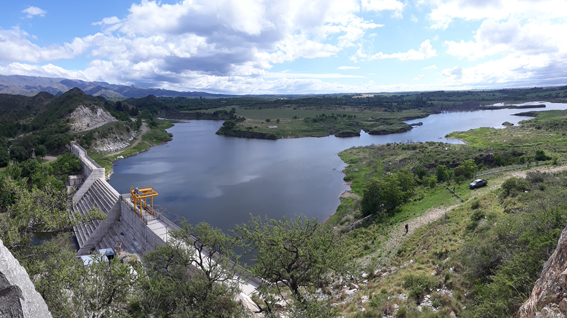
Los sedimentos que se desprenden por erosión de una zona del suelo pueden afectar a los ecosistemas circundantes. En la región semiárida del centro de la Argentina, los diferentes usos del suelo incrementan el volumen de los sedimentos que se transportan a lo largo de la red hidrológica del río Volcán, lo que afecta el estado de los recursos hídricos y colmata en más del 60 % el principal embalse de la región. “El dique de Cruz de Piedra ha perdido en gran parte su capacidad de contención y cada vez son más evidentes los signos de eutrofización”, afirma Velasco.

Mediante su programa de cooperación técnica, en colaboración con la FAO y en alianza con el Grupo de Estudios Ambientales del Instituto de Matemática Aplicada San Luis (IMASL), el OIEA determinó el tipo y la ubicación de las principales fuentes de sedimentos presentes en la cuenca mediante tecnología de fluorescencia de rayos X (XRF). Cuando se exponen muestras de suelo a este tipo de radiación, se emiten pequeñas cantidades de energía que se pueden medir con un espectrómetro. “La señal que nos da el instrumento nos permite determinar las concentraciones de los elementos químicos presentes en cada muestra de suelo, que dependen en gran medida del tipo de suelo, el sustrato geológico que conforma el subsuelo y el uso productivo que se desarrolla en el territorio”, puntualiza Velasco.

Se recolectaron aproximadamente 80 muestras de más de 20 fuentes de sedimentos alrededor del río Volcán y de 10 sitios de depósito de sedimentos al interior de él. Tras el análisis, los científicos concluyeron que, si bien es una zona con gran actividad agrícola, solo entre el 6 y el 16 % de los sedimentos provenía de los cultivos. Los resultados mostraron que la mayoría de los sedimentos se originaba en diminutos riachuelos que corrían por vías no pavimentadas y que muchos otros provenían de la erosión de las riberas.

espectometro-medicion-sedimientos-rio.jpg

Espectrómetro usado para analizar muestras de suelo en el río Volcán en la Argentina (Fotografía: H. Velasco/CONICET).

Con esta información, los científicos concluyeron que la siembra directa (sin labranza), principal práctica agrícola en la zona, reducía la erosión y que los esfuerzos por reducir el volumen de sedimentos en el agua debían concentrarse principalmente en la protección de las vías y riberas en la parte superior de la cuenca. 

En diferentes partes del mundo se están utilizando exitosamente técnicas de base nuclear para determinar el origen de los sedimentos y su transporte hasta su destino final. En particular, las investigaciones buscan dilucidar el impacto de las nuevas prácticas agropecuarias y el cambio climático sobre el suelo y el agua. Desde 1995, expertos de más de 70 países han contado con el apoyo del OIEA y la FAO para usar técnicas de base nuclear relacionadas con la gestión del suelo. La erosión afecta particularmente a los países de zonas tropicales, subtropicales y con climas áridos. Es mayor en África, donde afecta al 65 % de las tierras agrícolas, seguida de América Latina con un 51 % y Asia con un 38 %.

recoleccion-muestras-rio.jpg

Investigadores recogiendo muestras de suelo en el río Volcán en la región central de la Argentina (Fotografía: H. Velasco/CONICET).

What is soil erosion?

Soil erosion, the most common type of land degradation, is a natural process that displaces the upper layer of soil, which is where plants get most of their nutrients and water needed for growing. Erosion is accelerated by human activities, such as removing the natural vegetation that protects the lands’ surface and converting it to cultivated and pasturelands. Soil erosion is particularly damaging for countries in tropical, subtropical and arid climate zones. It is most prevalent in Africa, affecting 65 percent of cropland, followed by Latin America with 51 percent and Asia with 38 percent.

The impact of soil erosion runs far beyond food production. “Soil erosion significantly reduces cropland productivity and contributes to the pollution of watercourses, wetlands and lakes,” said Hugo Velasco, Professor at the Physics Department of San Luis National University and Independent Researcher at the National Research Council of Argentina (CONICET).

As soil disperses via waterways, sediments accumulate in reservoirs, diminishing their capacity and harming aquatic ecosystems and biodiversity. “This natural process becomes even more critical in arid and semi-arid zones due to two main reasons: agricultural areas were expanded at the expense of native forest cover, which disturbs the hydrological balance, and precipitation trends have increased with a higher frequency of extreme rainfall events,” Velasco explained.

In the last decades, nuclear techniques utilizing X-rays and environmental radionuclides, typically fallout radionuclides (FRNs) as tracers, were introduced to assess erosion rates and to identify the origin of the displaced sediments.

FRNs are naturally occurring or man-made radionuclides released into the atmosphere and deposited on the ground by rainfall in trace amounts. They strongly bind to soil particles, and the soil’s FRN concentration can be used to estimate soil erosion. If the FRN content of a studied area is lower than the amount found in an undisturbed, reference area, it means soil at the studied site has been lost to erosion.

Since 1995, experts in more than 70 countries have benefitted from support by the IAEA and the FAO in the use of nuclear techniques related to soil health and management.

Zimbabwe: Isotopes guide effective soil conservation practices

With an average of 450 to 600 mm of rain per year, large parts of Zimbabwe are semi-arid and experience limited water supply due to drought. This contributes to the challenges facing the agricultural sector, which plays a major role in its economy, employing about 67 percent of the workforce and comprising 45 percent of exports.

Year after year, “the consequences of erosion are seen in declining crop yields and high rates of siltation of reservoirs, especially of the smaller dams used for rural water supplies,” Chikwari said. The severity of land degradation led scientists to estimate that the cultivation of crops, such as maize, will only be possible for another 15 years before soils become too poor to support farming, and many small dams are likely to fill with sediments. Various soil conservation measures need to be implemented, but until recently it has not been clear how, Chikwari added. “Previous efforts to obtain information were based on direct measurements of soil losses, which required a lot of labour and capital investment.”

To quantify the effectiveness of various soil conservation strategies, the Chemistry and Soil Research Institute in Zimbabwe launched a study utilizing caesium-137 (Cs-137) isotopes. In the 1950s and 1960s, Cs-137 radionuclides were released into the atmosphere by nuclear weapon tests and deposited in soils worldwide. By measuring Cs-137 concentrations, scientists could estimate soil erosion rates, specifically to compare the erosion of plots with and without tillage.

Soil erosion rates under conventional tillage reached 6.2 ton per hectare per year (t/ha/y), while rates were nearly 55 percent lower at no-tillage plots, at only 2.8 t/ha/y. “With the results of the study, we have the knowledge to improve our soil conservation efforts, and in turn, increase food security,” Chikwari said.

Argentina: X-rays reveal the source of sediments deposited in water reservoirs

Loose sediments from an erosion site can affect surrounding ecosystems. In the semi-arid region of central Argentina, sediments have contaminated the Volcán river, threatening water resources and clogging the region’s main dam by more than 60 percent. “The Cruz de Piedra dam lost its storage capacity, and signs of eutrophication have become evident,” Velasco said.

The IAEA through its technical cooperation programme, in cooperation with the FAO and in partnership with the Environmental Studies Group of the San Luis Institute of Applied Mathematics, sought to determine the nature and location of the main sources of sediments transported by the river with X-ray fluorescence (XRF) technology. When soil elements are exposed to X-ray beams, small quantities of energy are emitted and detected by an XRF spectrometer. “These concentrations of energy are mainly conditioned by the type of soils, the geological substratum from which they originate and the land uses,” Velasco said.

Approximately 80 surface soil samples from 20 to 30 recognized sources of sediments surrounding the Volcán river and from 10 deposit sites in the river were collected. Though cultivated land occupied most of the studied area, it only contributed between 6 to 16 percent of the overall sediment composition. The XRF results showed that the major source of sediments is the removal of soil by concentrated water running through little streamlets along unpaved roads, followed by river bank erosion. Scientists concluded that soil conservation measures were not necessary on cultivated lands, so efforts should focus on maintaining roads and river banks in the upper part of the watershed to minimize erosion.

argentina-reservoir-la-estrechura-1140x640.jpg

Small water reservoirs, such as La Estrechura pictured, in Argentina are severely endangered by sedimentation, which reduced their volume and water storage capacity. (H. Velasco/CONICET)

Sri Lanka: Fallout radionuclides guide conservation practices, leading to a 42 percent reduction of soil losses

In Sri Lanka, terraced fields and gardens comprise the Central Highlands, producing tea, rubber, spices and vegetables. These fields contribute 20 percent of Sri Lanka’s GDP; however, this area is highly prone to soil erosion, which at one point reached almost 40 t/ha/yr of soil loss. The soil conservation programme requires reliable and representative data on soil erosion rates, spatial distribution and efficiency of conservation measures.

The IAEA through its technical cooperation programme, in cooperation with FAO and in collaboration with the Sri Lanka Atomic Energy Board and Natural Resources Management Centre, carried out the measurement of Cs-137 radionuclides to pinpoint areas for conservation activities to improve soil management.

By analysing the amount of Cs-137 concentration at different sites, scientists were able to identify specific locations for the deployment of conservation measures. Changing the shape and orientation of fields, planting vegetation under tea plants to stop soil from moving, creating stone barriers to hinder water runoff and planting leguminous trees significantly reduced soil losses. It was estimated that soil conservation activities in Central Highland tea plantations minimized annual soil erosion by 42 percent (from almost 40 t/ha/yr to 23 t/ha/yr).

sri-lanka-small-water-reservoirs-1140x640.jpg

Scientists in Sri Lanka used fallout radionuclides to identify specific locations for the deployment of conservation measures, which included changing the shape and orientation of fields. (Photo: Sri Lanka Atomic Energy Board)